It’s warming, which means we had an excuse to hike Virginia’s Peaks of Otter again. I say again because we attempted this trail a few weekends ago . . . when there was a winter storm advisory . . . when a large amount of snow was expected . . . and when below freezing temperatures were on their way. Needless to say, the weather won that day because when we arrived to the Jefferson National Forest, we were greeted with thick fog and temperatures so cold that I refused to leave the car after a brief roll-down of my window.
 Andrew didn’t mind either — He had stepped out to look at a map or something and raced back to the car. I’ve never seen a man run as fast. Then we drove, forlorn and irritable, back home. Hike done before it even started.
Sometimes hiking is like that though. Sometimes you just cannot go — for whatever reason — and I’m trying to learn that is okay. I’m trying.
So weekends passed until Andrew and I were discussing hiking again.
“Peaks of Otter?” I asked nervous. Even if it was warmer here, that did not mean it was warmer there.
“Know what?” he hesitated. I held my breath. “Let’s go for it.” I didn’t need more convincing.
So back we drove to Jefferson National Forest where we were greeted with a blue sky, sun, and green meadows. Essentially, a completely different view from our last visit so I leaned out the window to take pictures as Andrew swirled around the mountain.


We came for the Peaks of Otter consists of many trails. However, two of the toughest mountains are also the most well-known: Flat Top and Sharp Top. We had grand desires to hike both in one day, making it a little under ten miles, but (cut to the end of story) after a pretty good climb up Flat Top, we were worn out, breathing heavy, and ready to relax our legs. Therefore, here is a breakdown of Flat Top Mountain:
- Six-point-seven miles
- 1,540-foot elevation gain
- Level Four of Five Difficulty


We set off on the unblazed trail, which was fine with us because Nature lead the way — She seemed to whisper in yellows as various types of daffodils, unusual dogwoods, and fluffy dandelions spotlighted our path.


Following our path down, we crossed by a calm blue lake located in front of a lodge.
 This was the Lake Trail, and it gave a marvelous view of Sharp Top Mountain.
 Sharp Top is the most crowded mountain in the Peaks of Otter whereas Flat Top, on the other hand, is more secluded.
 Reaching Flat Top a couple miles later, we were warned the first one-point-four miles is straight up, lacking practically any switchbacks. This made our walk exhausting from the start.

 The pops of purple scattered along the path were appreciated not only for their beauty but because they gave me reason to pause on the incline.

Up and up we continued towards the blue sky. Soon a spur trail appeared on our right . . .
 This meant we were point-six miles from boulders that were a short distance from our first lookout.
 Flat Top Mountain, I soon learned, has a way of teasing hikers — The name sounds dry and mundane, and maybe that is why this trail is more secluded. However, I’m here to promise you the views are the opposite. I could see for miles and miles, past the point of vision because land and sky blurred together.

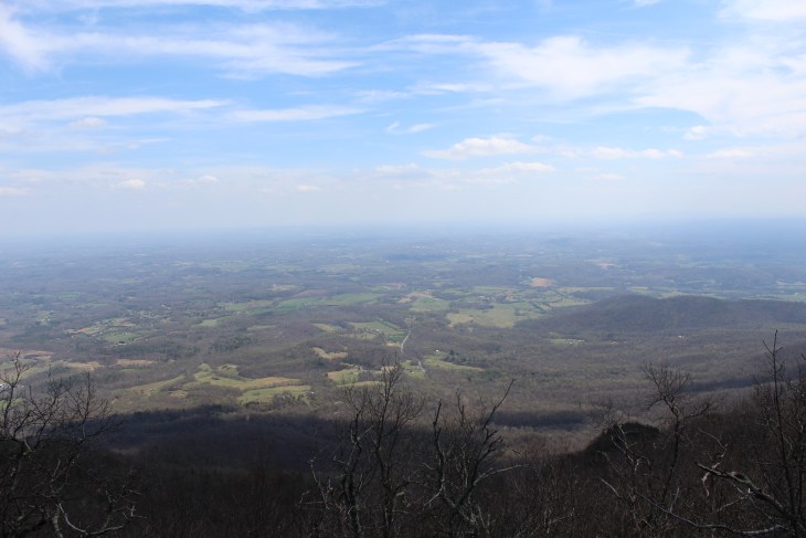
 Each look-out tempted me to stay and I found myself thinking, “Surely the sights cannot get better than this.” Every time, though, I was wrong in the best way possible.
Crawling down from the boulder, we skipped over white flowers called Blood Root that were sprinkled around the massive rocks. They popped through the brown leaves and dirt seeming full of excitement. Their bright white petals stretched, making me think the flowers were awakening from sleep, as their little yellow faces, yawning and reaching further still, absorbed the sun’s rays.


 Our summit view was a little over two miles away where we could see the boulders jutting from the mountain in the distance.
 We set off towards that distant spot until the mountain top appeared to curve before us.


At the summit, we darted left of the trail to avoid people that were at the main look-out on the right, and I was happy we did — The view all around us was incredible and we sat on the rocks for many moments, talking and eating our lunch.


 Leaving the birds and one view, we walked to the right of the trail where we pass US Coast and Geodetic Survey markers and a sign informing us that the summit of Flat Top Mountain is 4,001 feet.

 Next, we stepped through the trees and onto smoothed boulders. Dangling our legs over the mountain, all was calm and peaceful as we cuddled into one another, looking out at our wide view of Bedford and beyond. We were reminded Bedford lost more men than any other US city of similar size as it was home to the nineteen men that died in Normandy during the first phase of World War II’s D-Day landings.
 Below us, the Bedford reservoir could be seen — a bright turquoise blue — and next to us, red buds slowly swelled on trees before opening.


 Standing to go, we turned to walk back down the mountain and our steep declining trail. Bits of spring we had missed on the way up rose from the ground in vibrant colors.

 Soon, we were at the parking lot where we decided our legs were too sore to trek up Sharp Top Mountain. Opening our vehicle’s doors, we got inside — happy with our decision to go home and full of appreciation for even a few hours walk in the woods together.