I’ve been avid to hike longer trails, paths leading to camping, and I didn’t want to wait anymore. Winter has stretched itself endless, and I was no longer going to be patient. Camping was on my mind so camping was where I would go! As expected though, winter protested something strong and fierce — The weekend we planned to go, there was a winter storm advisory and heavy snow headed our way and below freezing temperatures. But my wilful personality knows no bounds . . . I just needed to convince Andy. I knew if I worded it right, he would see this as a challenge and if there is one thing Andrew doesn’t back down from, it’s a challenge. So the words “training for the Appalachian Trail” may have been used, and a “let’s go” from him may have been said.
So we pulled out our massive packs and began stuffing them while our rascals looked and smelled and wormed their way into our gear.


 All was glorious and happy so we set off into the mountains. And were greeted with this.
 As we drove, the snow became deeper and the visibility, less. We watched as the temperature dropped past thirty degrees and reached the twenties. Then roads were closed. Then “No camping” signs were seen so in the end we had to turn back.
I was miserable, to say the least.
We waited, leaving our packs packed as if willing winter to end. And it sorta worked. The following weekend carried warmer temperatures and beautiful weather so we were out once more, this time to George Washington National Forest’s Spy Rock:
- We chose hiking Crabtree Falls to Spy Rock, which is fourteen miles. (However, there are shorter trails to Spy Rock.)
- 3,610-foot elevation gain
- Rated Level Four of Five difficulty
I was eager for this hike: First, Spy Rock had been on my To Hike List since I started, but I was also happy for Andrew to finally see Crabtree’s waterfall. You may remember Crabtree Falls was my starting-out second hike, which I intended to invite Andrew but admittedly forgot him, only remembered I forgot him when I was at the mountain’s summit. He hasn’t let me live this down so I was happy to finally put an end to the fact that he had not hiked the Crabtree Trail. (More on this story in my This is Us post.)
Anyway we set off on a pleasant day, a day so lovely it begged pulling over to take pictures on the way up. Whenever I snap pictures, I see people rushing by the moments I have paused at — They believe the destination is more important than the journey. I disagree, strongly. In the past, I was too focused on the destination and missed appreciating the journey there. This is why I hope to always pause and not only appreciate the path but also reflect on where it started and where it is headed.

Pulling into the parking lot, we pulled on our packs and began walking.


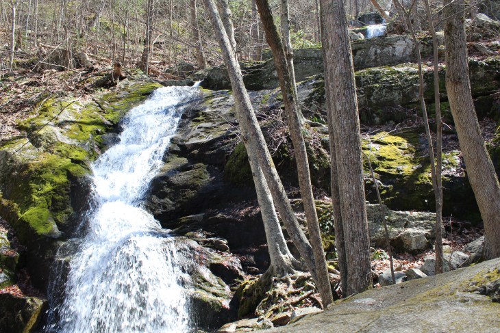
Crabtree Falls is made of a series of waterfalls — understandably called the lower, middle, and upper falls — where the water flows from Crabtree Meadows to the Tye River. In all, the waterfalls drops 1,080 feet though hanging valleys rare to the area.

 Continuing past the lower falls, the neighboring mountains came into more view.


Soon we were at the middle section of the falls. Each portion is different — For instance, the middle is a single drop of ninety feet over moss-covered rocks, which are closer to trees and plants.


 Moving up still, we followed switchbacks that twisted again towards the water.

 With the upper falls in sight, we trekked on until we reached the top of the falls, which plunges 200 feet over a cliff.

 Above the upper falls is a lovely vista of the area, but our journey didn’t end here.
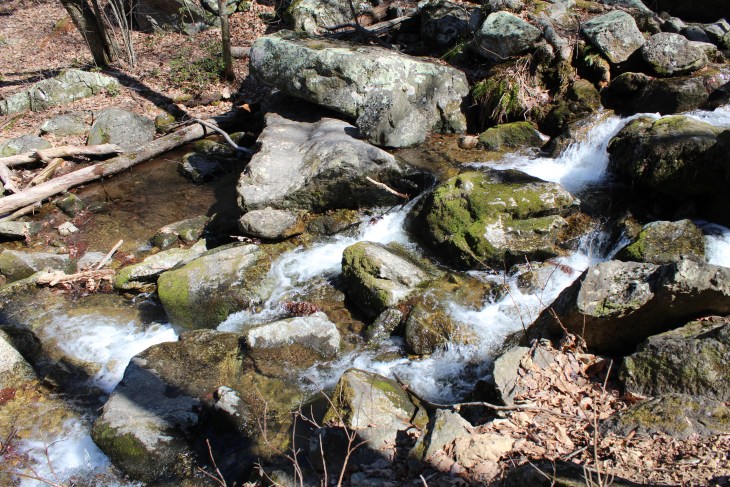
 Moving back to the Crabtree Falls Trail, we followed Crabtree Creek for a little over a mile.
 This part of the hike was one of the most beautiful — The sun streamed in at the right angle, making all appear rich and colorful.


 Crabtree Falls Trail leads to Crabtree Meadows, which we passed it on the right.

 Trekking on, we reached a forest road that intersects our beloved Appalachian Trail. There, we were greeted with more amazing views.
 Turning south on the white blaze, we had a camp destination in mind: a small site on a grassy clearing. With about three miles left to go, the sun began to drop behind neighboring mountains. Soon pastels lit the sky, which gave way to a blues blended together as if in a watercolor painting.


 And that is where camped for the night, our first camp of the year — Tucked behind large boulders and nestled above plush tan grass, we pitched our tent on the edge of a cliff face with a look at the Blue Ridge Mountains.
Passing up the opportunity to build a fire due to the freezing temperatures, we crawled into our tent and cuddled up under our sleeping bags, listening to the wind howl and shake our little tent. Unable to stake in a portion of our rainfly due to the rockface, the rainfly became more like a flag, thrashing back and forth throughout the night, starting on Andy’s side when we went to sleep until it whipped around to mine when we woke. I normally love listening to wind howl but it does keep me on edge when camping in the mountains, probably due to our ghostly-experience at Dark Hollow Falls, which I couldn’t seem to get out of my mind despite the fact that I felt safer at this spot more than any other we’ve camped in.
“Chap?” I whispered as he was about to fall asleep.
“Lass?” he whispered back.
“Chap, if I have to pee in the middle of the night, will you wake up with me? You don’t have to come outside but just in case something happens to me — I fall off the cliff or get attacked by an animal or killed by a person — will you just be awake to account for me not coming back?” This seemed a logical request.
“Okay,” he answered and the wind roared louder.
“Chap?” I whispered again.
“Lass?”
“Will you stay awake with me for a bit? I feel safe here but I haven’t gotten used to the sounds of the wind yet — It’s making me nervous.”
“Of course,” he responded and I immediately felt grateful to have him by my side until he let out the loudest pattern of deep-breathing snores and I knew he had fallen asleep after the word ‘course.’
This is how our camping normally goes — He is able to pass into deep sleep the moment his head hits the pillow while I seem to do the opposite and waken. I never sleep much when we camp — I am too alert — so morning can never come soon enough. This morning though was exceptionally beautiful with fiery pinks and oranges, melting to purples and blues, all stretched out in a calming sky.

“Good morning,” Andy whispered to me when he woke, hearing me get back into the tent.
“Hiya,” I whispered back. “What would I have to go to convince you to get up right now and hike Spy Rock on the chance we could catch a incredible sunset?” I knew I’d need to do a large amount of convincing and that he could fall asleep again — in the middle of conversation — just as easily as he did last night.
“Is the sun rising now?” he asked, yawning.
“Yes, just barely coming up — It’s the most vibrant of colors.” I held my breath. I hike for sunrises and sunsets, never seeming to be in the right place at the right time.
“Alright, let’s go,” he said without hesitation, surprising me. And so we were off, racing against the rising sun.
 Packing essential supplies in the top removable portion of my pack, we ditched our tent and gear then headed back on the AT towards Spy Rock, which was a mile and a half away.

 But if the rising sun was what we aimed to see on the summit, time was running out — The intensity of the sky’s color was fading faster and all around was slowly becoming lighter.
 Finally at the base of Spy Rock, we rock climbed, scrambled up. There are no paths or blazes here: You simply pick a route and keep trying until you reach the top.


 At the top, we watched as the last light oranges and pinks faded into a very cloudy sky.
 Spy Rock is rewarding to say the least — It is a massive rocky dome boasting a 360-degree view of the surrounding mountains, which Andrew was able to capture here.


Saying goodbye to one of the best views we’ve seen hiking thus far, we headed back down Spy Rock towards the Appalachian Trail.


 Returning to our campsite, the blues in the sky appeared burning, and it was under this sky we ate breakfast.
 The temperature felt as if it were dropping so I layered up — two pants and four shirts under my raincoat — and we set off down the AT.
 The farther we hiked, the more my feet began to slip in my boots under my pack weight. Previously I had done only day hikes in my Danner boots, which means my thirty pound pack was absent and therefore unable to exaggerate boot issues. This was the first longer trail I walked with them, and unfortunately it was here I learned the tri-fold tongue issues increased. I wrote more about these issues in my Gear Review: Hiking Boots II post, which I’ll ruin the ending: I had to return these beloved boots. Among other issues, the tri-fold tongue prevents the boots from being laced tight so my toes were hitting the front of my boots and the balls of my feet, heels, and ankles were rubbed raw from the sliding movement. This is why Andrew took pictures like this of me, absolutely in feet-pain and refusing to walk further until I had a good fifteen minutes to rest. I was miserable and even considered hiking in my socks the last three miles to alleviate the pain.
 Those last three miles dragged out too so much so that by the time we got to the car, Andy and I jumped in, ready to rest our sore feet.
 Dramatically more happy with our hiking boots off, we drove home proud of ourselves. Sometimes people can let the end of a journey, if bad, dampen the experience; but we found the opposite. Laughing and smiling as we zipped through the mountains, we felt our first camping trip of the year a success — We had jumped from a Level Two to Four, dramatically increased altitude, and went from an average five mile hike to fourteen. Whatever was in store on our future trails, we felt ready — eager and ready for more journeys and more mountain tales.
Morning. Another good read Bezzy. Love the photo’s of the Fungus and the Sunrise. You need to get him up earlier to get better vista’s of the Sun coming up. Midad. xx
I absolutely agree! Every time we hike I try to get him up earlier and earlier! Maybe 2018 will bring more sunrise and sunset hikes!